

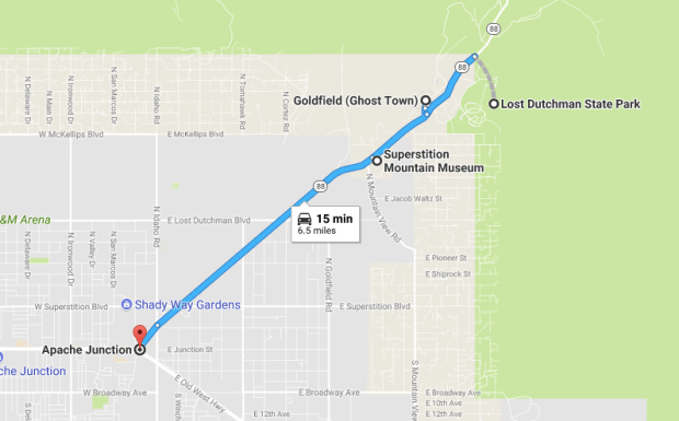
 Apache Junction may not seem like much, but for history buffs like myself, this little nook of Arizona has a slew of history to be uncovered. Shadowed by the eerie Superstition Mountains, Apache Junction sits at the intersection of the Apache Trail and U.S. Route 60, which runs roughly parallel to the better-known Route 66. And there is just as much old west history as you’d expect.
The Apache Trail was the old stagecoach route that ran through the Superstition Mountains. Named after the Apache Indians who originally used it, most of it still remains unpaved but takes you past nearby Canyon and Apache Lake. If you’re new to the area, you might be surprised to learn that the the road has daunting, steep cliffs and not much to protect you from natural dangers. Welcome to the Arizona wilderness.
Perhaps the legacy of the Superstition Mountains really gained traction when explorer Jacob Waltz, the now famous “Lost Dutchman” (who was really German), actually “found the gold.” But the mountain’s reputation was spread far and wide long before Jacob arrived. The Apaches conquered the mountains first, followed by Spanish conquistadors, the Peralta family, who came North from Mexico in 1540 seeking gold.
 The Apaches were not happy with the Spaniards’ arrival. They eventually found their own gold in the mountains and the Apaches were unsettled by their presence, especially when the the conquistadors took a liking to the Apache women, so the story goes. Just when the Peralta group was convinced to pack up, board up and leave the mine they found, the Apaches planned a sneak attack and massacred the entire company of Spaniards. Hundreds of them, in 1848 at a place now known as the Massacre Grounds, and coincidentally an excellent hike to explore Lost Dutchman State Park. And this was just the beginning of a series of mysterious disappearances and deaths that occurred in the midst of the Superstition Mountains, in case you were wondering where it got its name.
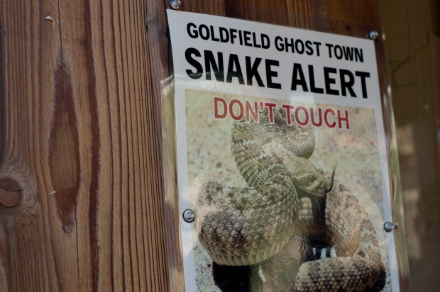
 The Massacre Grounds Trail is a roughly 5-6 mile roundtrip hike (there and back) and provides some wonderful views without the steep cliff climbs of some of the park’s trails (i.e Flatiron via Siphone Draw, discussed below). While it is labeled as physically “easy” on Alltrails.com it isn’t without its dangers of snakes and heat exhaustion. Don’t do this hike in the summer if you’ve never hiked in Arizona before. Parking for the trail is not well marked and difficult to find.
To get there: Take the second exit on the right for Lost Dutchman State Park trails (2nd if you’re coming from Apache Junction), continue past the first dirt parking area on your immediate left, and past the “rough road” warning (just to the trailhead, the road is just a regular dirt road), to the official parking lot for Crosscut Trailhead on the road to First Water Trailhead. At the parking lot trailhead, find the one for Massacre Grounds Trail (to your left) and continue along the wash to the East until you see a path just a few steps ahead that goes between trees on the right. It is completely unmarked. It is obvious that it is a well traveled path, so you’ll know that you’re on the correct one as you go along. This website describes the hike well. In the warmer months it is an eerily silent hike and it’s easy to accidentally hear strange noises or see movement in the distance.
Be sure to go early to avoid the heat, it will quickly catch up with you. I also wouldn’t go without at least 2 liters of water. When I went during August, I set out on the trail at sunrise and was back to the car just as it was getting uncomfortably warm. As a good general rule of thumb for desert hiking, the following things are something you should ALWAYS, at bare minimum, keep in mind during your desert hikes:
- Do NOT wear flip flops (apparently this actually happens?)
- Do NOT go near snakes, keep and eye out for them, and remember that their strike range is about of two-thirds their total body length. I.e: A 3 ft snake could strike a distance of two feet. Always keep a safe distance from any snake.
- Bring at least 2 liters of water. Preferably more if you are larger than a 5’7 woman.
- I also recommend the classic 10 essentials.
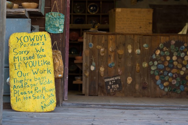
 After any of the park’s hikes, Goldfield Ghost Town and its signature Mammoth Saloon is a fantastic place to grab a bite (epic hamburgers) and a beer (or Prickly Pear Margarita!). My favorite grub is a fish sandwich and a side of Rodeo amber ale. They won’t skimp out on your seasoned, crispy fries either.
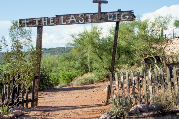
Goldfield rose around 1893 after the waning years of the California Gold Rush and in the midst of the Klondike Gold Rush.
In the 1890′s, “Goldfield had 3 saloons, a boarding house, general store, blacksmith shop, brewery, meat market and a school house. Just when it looked like the town would outgrow Mesa, the vein faulted, the grade of ore dropped and the town died a slow painful death,” (goldfieldghosttown.com).
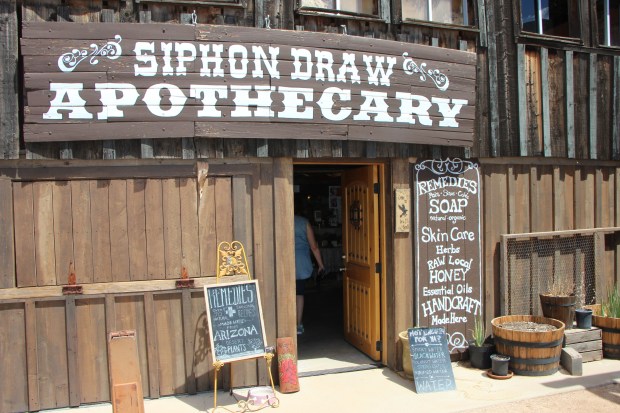 It was the ideal hangout for outlaws and those looking to strike it rich, hot on the to tail of the famed Lost Dutchman’s gold. Today you can watch live reenactments, take tours of a gold mine, satisfy your sweet tooth with Sarsparilla, ice cream or something at the bakery, or find the perfect desert souvenir with local soaps, honeys and more at the Siphon Draw Apothecary. Turquoise, Native American rugs or real Lost Dutchman gold dusted fudge can be found at other merchant’s shops. The town’s buildings have remained surprisingly in tact, original and functional.
According to the tale, Jacob Waltz (aka The Lost Dutchman) allegedly found the Peralta’s gold and took the secret location to his deathbed. It is yet to be found, but starting your Lost Dutchman treasure hunting at Goldfield will set you up with the necessary panning material and a quick lesson on gold panning before you head up the mountain.

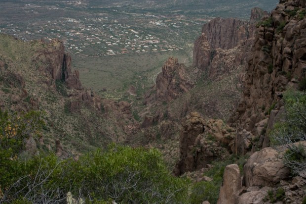
- View towards Goldfield and Apache Junction from atop the Flatiron
There are many hikes to explore in Lost Dutchman State Park, and supposedly much of the area is still uncharted, perhaps why the gold is yet to be found. Living in the shadow of the great Superstitions, I had a yearning to make it to the top of them. This is how I found out about the Flatiron via Siphon Draw hike.
Not for the faint of heart, the 5-6 hour hike/climb to the Flatiron will challenge even an experienced hiker! I braved the hike on an early August morning, setting out at sunrise (5:30am). You will need a $7 (as of 2017) State Park parking pass for your vehicle. We shuffled, stiff legged and exhausted back to the car at 10:30am, just as it hit over 95 degrees. If you plan to hike this, don’t slack on the water, it’s over 3,000 feet of elevation gain with little reprieve, topping out at the Flatiron’s 4,861 feet. I brought 2 liters in my trusty Camelback daypack/hydration pack, which I don’t hike without, and an additional bottle in my day pack. I drank it all, and could have drank more. You’ll want a snack for the top, you will burn a full day’s worth of calories getting there! About halfway up, just as it starts to get tricky there is blue paint on rocks that pop up at opportune times to keep you on the right path. They’re easy to miss though, if you’re not watching for them. You can read more about the hike on Arizona Hikers Guide.
***A note on dogs. Dogs are allowed on this trail, but it isn’t dog ‘friendly’. I debated bringing my hike-savvy Australian Shepherd mix, Hank, didn’t, and it was definitely the right decision. I would have ended up carrying him through many of the top sections and a lot of the rocky areas would have really shred his paws, and it was way too hot by the last hour of it. Maybe on a cold winter day I’ll let him brave it, but any time outside of November-March would be too much.
If there were any lingering Lost Dutchman or Apache spirits in the air around this hike to the top of the Superstitions, I was too enthralled by the physical demands of the hike to remember to notice.
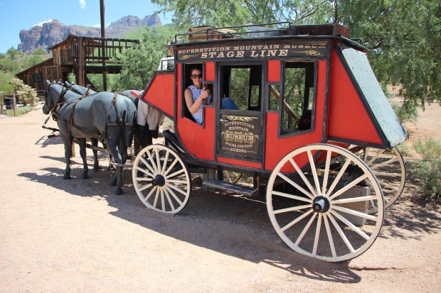
For some calmer thrills, spend a few hours perusing the Atlas Obscura featured grounds of the Superstition Mountain Museum and remnants of Apacheland Movie Ranch, where they filmed many of your favorite old west films. You can pay $5 to view the stones holding the clues to the Lost Dutchman Mine, some serious Sonoran Desert taxidermy and memorabilia from famous Westerns, or wander around the Elvis Chapel and Apacheland Barn, which were featured in movies like Kenny Rogers’ The Gambler, and Elvis Presley’s Charro! among others. The grounds are also host to a blacksmith, a labyrinth and a massive, 21′ stamp mill, that provides regular free demonstrations. You can find more about the museum on their website.
 After a day of exploring and gold panning, you can spend a night on the town at one of the area’s favorite watering holes, right along the road to the Lost Dutchman State Park. The Hitching Post Saloon and pizza parlor is home to live bull riding, live bands with line dancing on a real wooden dance floor and a rare chance for you to order genuine rattlesnake. There’s a bucket of beer special (and local craft beers on tap) and you can park your horse right out front, if you’re into that. It’s about as modern wild west as you can get, and the pizza isn’t half bad, either!
Welcome to the Arizona.
NOTE: This blog includes affiliate links, which means I may receive a nominal commission when you make a purchase at no additional cost to you. I have not been paid for my opinion and any commentary on the efficiency of a product is solely my own opinion and experience.

Hi, Kaysha! I work with the Yuma Visitors Bureau and saw a photo of yours we’d love to use alongside our article on Telegraph Pass in this year’s visitors guide. (http://www.trover.com/d/ZM9p-telegraph-pass-trail-fortuna-foothills-arizona) Would you be willing to share that with us? If so, can you shoot me an email with the high res version and we’ll pop it onto the page with a photo credit and a link to your website (or instagram feed, whatever you like). Thanks for your consideration!
-Paige Lineberry
Hi Paige! I couldn’t find your contact information on the YVB page, but I don’t think I have that photo in high resolution anywhere anymore. You can absolutely share it where you see fit, but you would have to just download it from Trover, unfortunately.
Thhis was lovely to read